Stop 2: Boundary Stone-Information
Boundaries of whatever sort usually followed or used prominent landscape features to mark their route. These could be prehistoric barrows, streams or prominent long-lived trees such as yews or oaks. Later, deliberate man-made markers such as linear ditches and banks or even more recently boundary stones, were used.
The Domesday Book, a survey made a few years after the Norman Conquest, recorded all the Manors, with the rents paid, the areas of the lands held, and even such details as salterns and mills. In this book the Manors of Bourne (now Westbourne) and Warblington are thrown together and stated to be held by Roger de Monte Gomeri (Montgomery).
The boundary of the old parish of Emsworth remained unchanged until 1902 and is of considerable antiquity, probably dating back to the Reign of Alfred the Great.
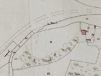
This is a part of the Tithe Map of Warblington Parish, dated 1841. In this map the boundary stone is located where the word “ post” is clearly marked. (Tithe Maps were prepared following the 1836 Commutation Act which allowed Tithes to be paid in cash rather than goods).
Before the railway arrived there was a marker – “stump” where the bridge is now located.
The Parish of Rowlands Castle was formed in 1932 consisting of Blendworth Parish, Idsworth Parish (which had been attached to Chalton at one time) and parts of five other Parishes, including Warblington. One of these, Havant (Redhill), provided Rowlands Castle with a church: the Church of St. John, built in 1837 (registers date from 1841).
Rowlands Castle is now a Ward and a Parish Council area within the East Hampshire Local Government District. It is also part of the East Hampshire UK Parliament constituency. This was previously Meon Valley, represented in the House of Commons of the UK Parliament by Flick Drummond, a Conservative, since 2019. It had previously been represented since its 2010 creation by George Hollingbery.